Curriculum Vitae
- Education
- Research Interests
- Work Experience
- Projects
- Selected Publications
- Academic Reports
- Invited Talks
- Honors & Awards
- Journal Reviewer
Dr. Junsheng Ding [pdf]
Postdoc@LSGI PolyU
The Hong Kong Polytechnic University, Hong Kong 999077, China
E-mail: junsheng.ding@polyu.edu.hk; junshengding@yeah.net
Personal Website: https://dingjunsheng.top
Research Gate: https://www.researchgate.net/profile/Junsheng_Ding
Google Scholar: https://scholar.google.com/citations?user=nkItmXUAAAAJ&hl=en&oi=ao
Education
- 2018-2023, PhD, Geodesy, University of Chinese Academy of Sciences, Beijing, China
- 2018-2023, PhD, Geodesy, Shanghai Astronomical Observatory, CAS, Shanghai, China
- 2014-2018, BSc, Geomatics Engineering, Chang’an University, Xi’an, China
Research Interests
- Satellite Navigation & Remote Sensing
- GNSS Meteorology & AI for Geodesy
Work Experience
- 2023.7-Present, Postdoctoral Fellow, The Hong Kong Polytechnic University, Hong Kong, China
- 2019.9-2021.9, Research Assistant, Shanghai Astronomical Observatory, CAS, Shanghai, China
- 2018.7-2018.8, Summer Trainee, National Institute of Metrology, China, Beijing, China
- 2017.7-2017.8, Software testing intern, Trimble R&D Center in China, Trimble Inc., Xi’an, China
Projects
- Postdoc Matching Fund Scheme, The Hong Kong Polytechnic University.
- Research Project on Enhancing High-Precision Positioning Network Capabilities (participant)
- GNSS Kinematic Reference Stations with Chip Scale Atomic ClockAiding for Offshore Real-Time Kinematic (RTK) Positioning (participant)
- PPP-RTK Regional Products Generation (participant)
Selected Publications
|
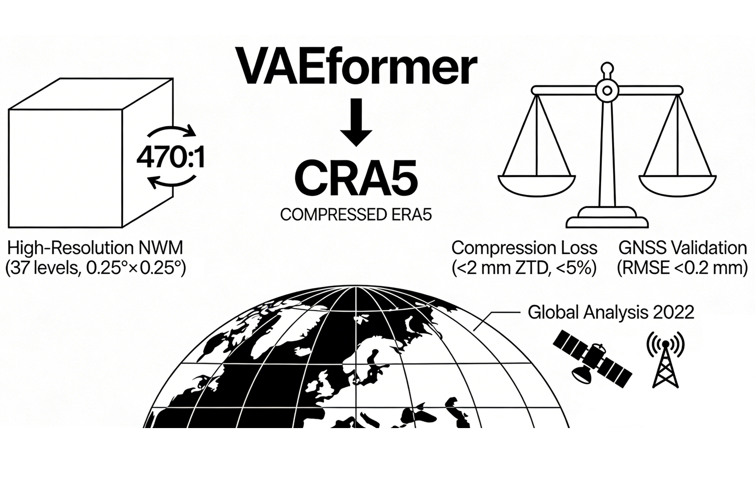
Impact of VBAEformer Compression Algorithm Precision Loss on the Tropospheric Delays for Microwave Remote Sensing Ding J, Xu C, Chen W, Chen J, Wang J, Zhang Y, Bai L, Han T, Xiong Y IEEE Transactions on Geoscience and Remote Sensing, 2025, 63, 4107311 [Paper] [WeChat News] [Website] |
|
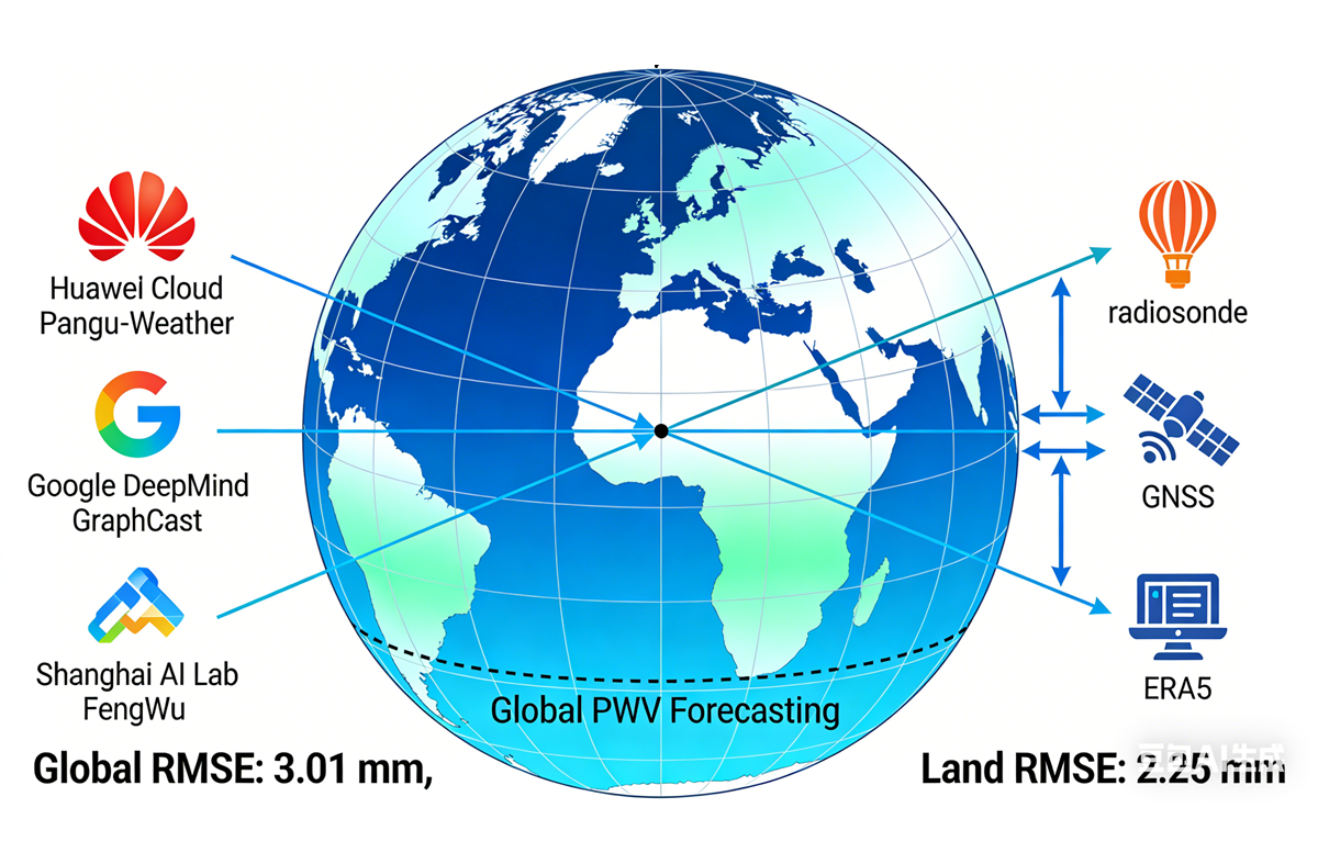
Real-Time High-Resolution Global PWV Retrieval Based on Weather Forecast Foundation Models and Cross-Validation With Radiosonde, GNSS, and ERA5 Ding J, Chen W, Chen J, Wang J, Zhang Y, Bai L IEEE JSTARS, 2025, 18, 15972-15981 [Paper] [WeChat News] [Website] |
|
A Novel Network RTK Technique for Mobile Platforms: Extending High-Precision Positioning to Offshore Environments Chen W, Ding J, Wang Y, Mi X, Liu T TransNav Journal, 2025, 19(2), 371-380 [Paper] [TransNav 2025] [BibTeX] |
|
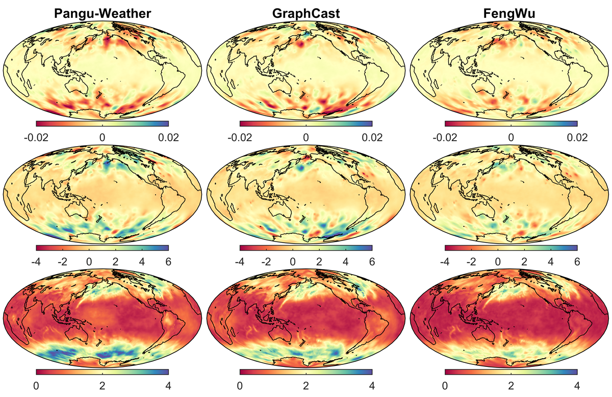
Spatiotemporal Inhomogeneity of Accuracy Degradation in AI Weather Forecast Foundation Models: A GNSS perspective Ding J, Chen W, Chen J, Wang J, Zhang Y, Bai L, Wang Y, Mi X, Liu T, Weng D Int J Appl Earth Obs (JAG), 2025, 139, 104473 [Paper] [Supplementary Data] [WeChat News] [Website] |
|
AI Foundation Models Facilitate Real-time Global GNSS PWV Retrieval with Sub-millimeter Accuracy Ding J, Chen W, Chen J, Wang J, Zhang Y, Weng D, Liu T, Mi X, Soja B, Bai L ESS Open Archive, July 12, 2024 [Preprint] [Poster] [BibTeX] |

|
Forecasting of Tropospheric Delay using AI Foundation Models Ding J, Mi X, Chen W, Chen J, Wang J, Zhang Y, Awange JL, Soja B, Bai L, Deng Y, Tang W IEEE Transactions on Geoscience and Remote Sensing, 2024, 62, 5803019 [Preprint] [Paper] [WeChat News] [Presentation] [CPGNSS 2025] [Website] |
|
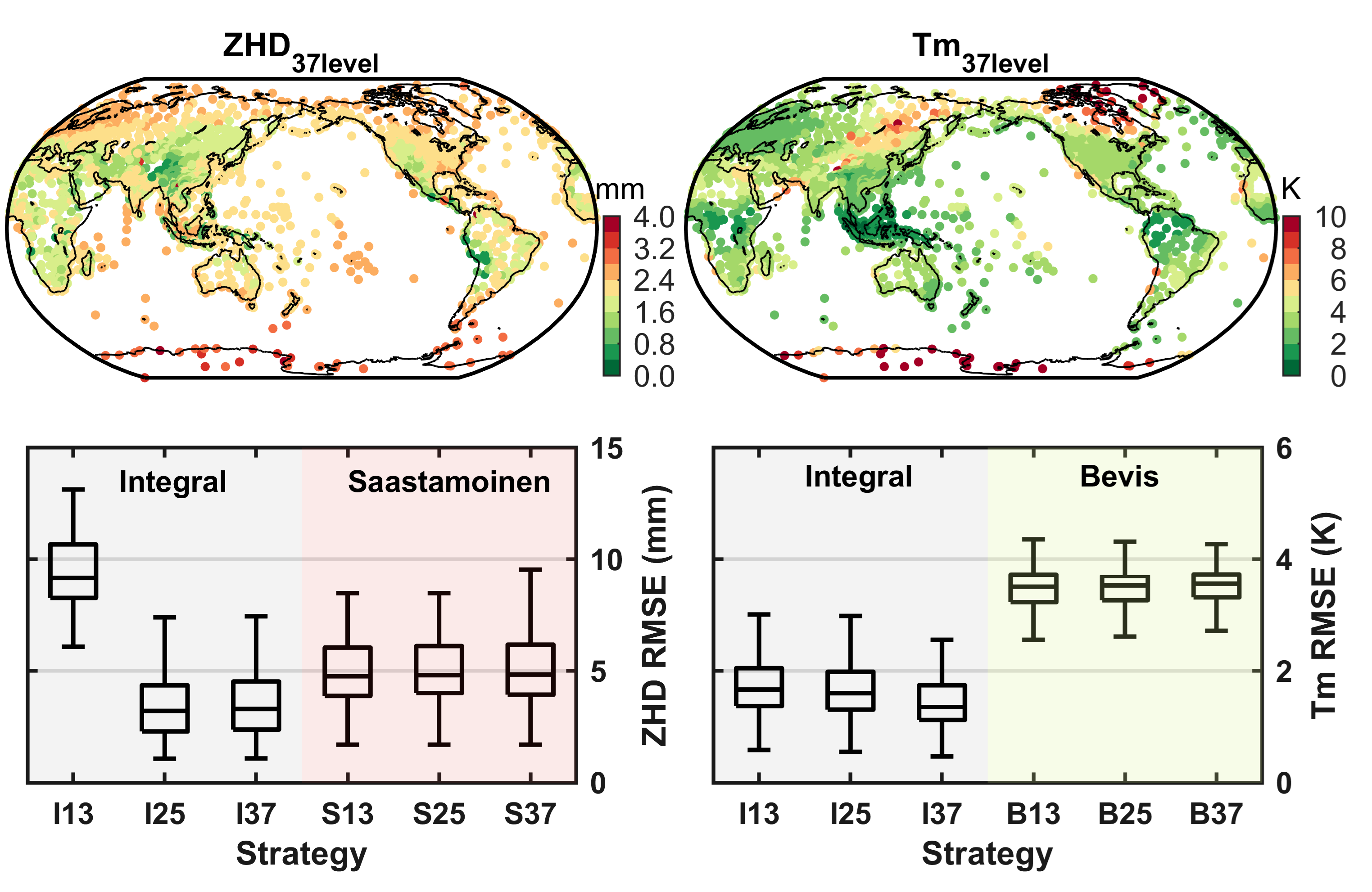
A Novel Method for Tropospheric Delay Mapping Function Vertical Modelling Ding J, Chen J, Wang J and Zhang Y Journal of Geodesy, 2024, 98, 37 [Paper] [Code] [BibTeX] |
|
Characteristic Differences in Tropospheric Delay between NGL Products and NWM Ray-tracing Ding J, Chen J, Wang J and Zhang Y GPS Solutions, 2023, 27, 47 [Paper] [BibTeX] |
More
- Liu T, Chen W, Mi X, Chen X, Yang Y Ding J, et al. (2026) Ionospheric nonlinear interpolation model for Mid- and Low-latitude network RTK during solar maxima. GPS Solutions, doi:10.1007/s10291-025-01976-9.
- Deng Y, Chen W, Ding J, El-Mowaf A, et al. (2025) Improving GNSS precise point positioning with tropospheric constraints from data-driven numerical weather prediction model. Geo-spatial Information Science, doi:10.1080/10095020.2025.2513650.
- Chen J, Song Z, Zhang Y, Ding J, et al. (2025) Clock systematic jump estimation and URA refinement of BDS-3 B2b real-time precise point positioning service. GPS Solutions, doi:10.1007/s10291-025-01835-7.
- Bai Q, Kong Q, Mi X, Chen W, Ding J, et al. (2025) Evaluation and analysis of the precipitable water vapor in Inner Mongolia of China. Earth Planets Space, doi:10.1186/s40623-025-02157-1.
- Tang W, Chen J, Zhang Y, Ding J (2024) Analysis of GNSS/Pseudolite Integrated Positioning Accuracy in Urban Canyon Environment. 2024 14th International Conference on Indoor Positioning and Indoor Navigation (IPIN), doi:10.1109/IPIN62893.2024.10786141.
- Ding J (2024) Research on GNSS tropospheric delay modeling and spatial-temporal characteristics analysis of bias. Acta Geodaetica et Cartographica Sinica, (Abstract of PhD thesis, in Chinese) doi:10.11947/j.AGCS.2024.20230177.
- Tang W, Chen J, Zhang Y, Ding J and Song Z (2024) Refined Troposphere Delay Models by NWM Ray-tracing for Pseudolite Positioning System and Their Performance Assessment. Advances in Space Research, doi:10.1016/j.asr.2024.02.034.
- Song Z, Chen J, Zhang Y, Yu C and Ding J (2023) Real-time Multi-GNSS Precise Point Positioning with Ambiguity Resolution Based on the BDS-3 Global Short-message Communication Function. GPS Solutions, doi:10.1007/s10291-023-01477-7.
- Ding J Chen J, Tang W and Song Z (2022) Spatial–Temporal Variability of Global GNSS-Derived PWV (1994–2020) and Climate Implications. Remote Sensing, doi:10.3390/rs14143493.
- Cui J, Chen J, Wang B, Yu C, Ding J and Wang R (2022) Characteristic Analysis of Satellite DCB Products Provided by CAS and DLR. Progress in Astronomy, (in Chinese) doi:10.3969/j.issn.1000-8349.2022.03.01.
- Ding J, Chen J and Tang W (2022) Increasing Trend of Precipitable Water Vapor in Antarctica and Greenland. China Satellite Navigation Conference 2022, Lecture Notes in Electrical Engineering, doi:10.1007/978-981-19-2588-7_27.
- Chen J, Zhang Y, Yu C and Ding J (2022) Processing Algorithms and Performance Evaluation of BDS RDSS Location Reporting Service. Acta Geodaetica et Cartographica Sinica, (in Chinese) doi:10.11947/j.AGCS.2022.20220024.
- Tang W, Chen J, Yu C, Ding J and Wang R (2021) A New Ground-based Pseudolite System Deployment Algorithm Based on MOPSO. Sensors, doi:10.3390/s21165364.
- Ding J and Chen J (2021) Accuracy Variability of GNSS PWV in the Range of Small and Medium Scale Areas. China Satellite Navigation Conference, CSNC 2021, doi:10.26914/c.cnkihy.2021.002146
- Chen Q, Chen J, Yu C, Zhang Y and Ding J (2020) Comparison of BDS Station Clock Short-term Prediction Models and their Applications in Precise Orbit Determination. Chinese Astronomy and Astrophysics, doi:10.1016/j.chinastron.2020.05.008.
- Ding J and Chen J (2020) Assessment of Empirical Troposphere Model GPT3 Based on NGL’s Global Troposphere Products. Sensors, doi:10.3390/s20133631.
- Chen J, Wang J, Wang A, Ding J and Zhang Y (2020) SHAtropE—A Regional Gridded ZTD Model for China and the Surrounding Areas. Remote Sensing, doi:10.3390/rs12010165.
- Ding J, Chen J and Wang J (2020) Quality Control Method for ZTD Modeling Based on GNSS Observation Data. Journal of Astronautics (in Chinese), doi:10.3873/j.issn.1000-1328.2020.09.010
Academic Reports
- International Association of Professionals in Global Navigation Satellite Systems (CPGNSS) Forum 2025, Oral, 19–20 Jul., 2025, Nanchang.
- Croucher Advanced Study Institute (ASI)——Revolutionizing Weather Forecast and Climate Prediction Through Artificial Intelligence, Poster, 19–21 Sep, 2024, Hong Kong
European Navigation Conference (ENC 2023), Oral, 31 May–2 June, 2023, Noordwijk, Netherlands.- China Satellite Navigation Conference (CSNC 2022), Oral, 25–27 May, 2022, Beijing.
- EGU General Assembly 2022 (EGU 2022), Oral, 23–27 May, 2022, Vienna, Austria.[link][pdf]
- 4-th Congress of China Geodesy and Geophysics (4-th CCGG), Oral, 17–18 July, 2021, Qingdao. [link]
- Scientific Assembly of the International Association Geodesy (IAG 2021), Oral, 28 June – July 2, 2021, Beijing. [link][pdf]
- International Association of Professionals in Global Positioning Systems (CPGPS) Forum 2020, Oral, 12–15 Nov., 2020, Shanghai. [link]
Invited Talks
- Generation and evaluation of high-precision satellite navigation tropospheric products based on AI foundation models, 20-26 Sep., 2024, Chang’an University, Xi’an, China.
- Space geodetic tropospheric delay forecasting based on foundation models, 23 Oct., 2025, Sun Yat-sen University, Zhuhai, China.
Honors & Awards
- Outstanding Graduates of Shanghai (2023)
- National Scholarship for Doctoral Students, CNY 30K (2022)
- Zhu-Li-Yuehua Outstanding Doctoral Scholarship of CAS, CNY 5K (2022)
- First Class Academic Scholarship of UCAS, CNY 15K (2021, 2022)
- Merit Student of University of Chinese Academy of Sciences (2020, 2021, 2022, 2023)
- Individual Scholarship of Chang’an University, CNY 500 (2017)
- The Third Prize of the 10th Challenge Cup Competition of Chang’an University (2017)
- The First Prize of the 10th Challenge Cup Competition of Chang’an University (2017)
- National Scholarship for Encouragement, CNY 5K (2016)
- The Third Prize of the 4th ACM-ICPC in Shaanxi Province (2016)
- The HI-TARGET Scholarship, CNY 3K (2015)
- Ding Family “Zhong Cheng” Education Scholarship, CNY 2.6K (2014)
- The National Third Prize of the 21st National Applied Physics Knowledge Contest (2011)
Journal Reviewer
Journal of Geodesy, GPS Solutions, IEEE TGRS, IEEE J-STARS, IEEE GRSL, IEEE TAES, Space Weather, Advances in Space Research, Geo-spatial Information Science, Measurement, Geodesy and Geodynamics, Remote Sensing, Scientific Reports, Geoscience Letters
Content